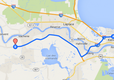
Oak Alley is an hour’s drive from New Orleans and Baton Rouge on the Great River Road. Use map below for directions on how to get here.

Google Map
Directions from New Orleans to Oak Alley Plantation
Take Interstate 10 (West) to Interstate 310 (South). Exit #220 – for Boutte. Continue on Interstate 310 across the Destrehan/Luling Bridge to exit #10 – for Donaldsonville, Highway 3127. Travel twenty-three (23) miles on Highway 3127 to major intersection with Highway 20. Turn right on Highway 20, travel three (3) miles to Highway 18, turn left and travel three (3) miles to Oak Alley Plantation.
Alternate rouge: Take Interstate 10 (West) to the Gramercy Exit #194. Turn left on Highway 641 (South). Follow Highway 641 (South), which will turn into Highway 3213. Continue on Highway 3213 over the Veteran’s Memorial Bridge (also known as Gramercy/Wallace Bridge). Take the exit on the down ramp toward Vacherie. Turn left onto Highway 18 and travel seven and one-half (7 1/2 ) miles to Oak Alley Plantation.
Directions from New Orleans International Airport to Oak Alley Plantation
Follow signs to 1-10W. Turn left and merge onto 1-10W. Follow I-310 S and LA_3127 N to LA-20 in Vacherie. Merge onto 1-10W. Take exit 220 for I-310 S toward Boutte/Houma. Continue onto I-310 S and take exit 10 for LA-3127 N toward Donaldsonville. Continue onto LA-3127 N for about 21.9 miles. Turn right onto LA-20 E. In 2.8 miles, turn left onto LA-18W. In 3.2 miles Oak Alley will be on your left.
Alternative Directions: Follow signs to 1-10W. Turn left and merge onto 1-10W. Continue on I-10W for 15.4 miles and take the LA-641 S exit toward Gramercy. Continue on LA-641 S. Turn left on Highway 641 (South). Follow Highway 641 (South), which will turn into Highway 3213. Continue on Highway 3213 over the Veteran’s Memorial Bridge (also known as Gramercy/Wallace Bridge). Take the exit on the down ramp toward Vacherie. Turn left onto Highway 18 and travel seven and one-half (7 1/2 ) miles to Oak Alley Plantation.
Directions from Baton Rouge to Oak Alley Plantation
Take Interstate 10 (East) to exit #194. Turn right on Highway 641 (South). Follow Highway 641 (South), which will turn into Highway 3213. Continue on Highway 3213 over the Veteran’s Memorial Bridge (also known as Gramercy/Wallace Bridge). Take the exit on the down ramp toward Vacherie. Turn left onto Highway 18 and travel seven and one-half miles to Oak Alley Plantation.
Oak Alley Plantation’s
GPS coordinates
N 30.00500
W 90.77889
